


Colorado River Basin sees ‘spectacular’ snowpack, buying time for big decisions
The Colorado River is one of the West’s most vital resources. But 20 years of drought have stressed the entire river basin, forcing federal officials to call for massive cuts in water use. This winter, in the water-towers of the west, storms have dropped more than double the average snowpack in some Colorado mountains. But after decades of overuse, drought, and rising temperatures, is it enough to replenish the system? (Video by Skyler Ballard/ The Gazette)
{
“@context”: “https://schema.org”,
“@type”: “VideoObject”,
“name”: “NEWS | Why a good snow year can’t save the Colorado River”,
“description”: “The Colorado River is one of the West’s most vital resources. But 20 years of drought have stressed the entire river basin, forcing federal officials to call for massive cuts in water use. This winter, in the water-towers of the west, storms have dropped more than double the average snowpack in some Colorado mountains. But after decades of overuse, drought, and rising temperatures, is it enough to replenish the system? (Video by Skyler Ballard/ The Gazette)”,
“thumbnailUrl”: “https://bloximages.newyork1.vip.townnews.com/denvergazette.com/content/tncms/assets/v3/editorial/f/a1/fa1f03da-d14f-5d52-92ee-3400cfe070a6/64314a79d201e.image.jpg?resize=1396%2C785”,
“uploadDate”: “2023-04-07T23:42:00-06:00”,
“contentUrl”: “https://cdn.field59.com/GAZETTE/0493693010de72837f28f20727c4901933eae63c_fl9-360p.mp4”
}
Heavy snowfall descended on Berthoud Pass in March as Brian Domonkos explained how scientists quantify the bountiful snowpack in some areas on the Colorado River Basin that could fend off federal emergency water measures — at least, for now.
The work depends heavily on SNOTEL (snow telemetry) sites — scientific outposts in the wild — collecting key data points that pile up like the snowflakes and help tell a critical story each season, said Domonkos, a Colorado snow survey supervisor with the Natural Resources Conservation Service.

Snow blankets a SNOTEL site at Berthoud Pass on March 2, 2023. SNOTEL sites are remote backcountry weather stations that measure snow and transmit the data wirelessly, which help inform decisions about water management.
Parker Seibold, The Gazette

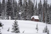
Snow blankets a SNOTEL site at Berthoud Pass on March 2, 2023. SNOTEL sites are remote backcountry weather stations that measure snow and transmit the data wirelessly, which help inform decisions about water management.
After trekking to the SNOTEL site on skis amid snow-laden evergreens, Domonkos described the numerous sensors at work, including a scale weighing the snow, sound waves measuring snow depth, sensors taking the temperature of different layers of snow and a gauge capturing all precipitation.
While satellite imagery can provide some snowpack data, SNOTEL sites provide some of the highest-quality numbers on how much water cities, farmers and recreationists can expect in the spring and summer. It’s key information collected across 900 SNOTEL sites in the West where about up to 80% of the water comes from mountain snowmelt, Domonkos said.

Brian Domonkos, the snow survey supervisor for the Natural Resources Conservation Service, gets ready to take a measurement at the Berthoud Pass SNOTEL site on March 2.
Parker Seibold, The Gazette

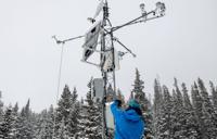
Brian Domonkos, the snow survey supervisor for the Natural Resources Conservation Service, gets ready to take a measurement at the Berthoud Pass SNOTEL site on March 2.

Brian Domonkos, the snow survey supervisor for the Natural Resources Conservation Service, takes a snow measurement at the Berthoud Pass SNOTEL site on March 2.
Parker Seibold, The Gazette

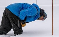
Brian Domonkos, the snow survey supervisor for the Natural Resources Conservation Service, takes a snow measurement at the Berthoud Pass SNOTEL site on March 2.

Snow falls around Brian Domonkos, the snow survey supervisor for the Natural Resources Conservation Service, as he treks into a SNOTEL site on Berthoud Pass on Thursday.
Parker Seibold, The Gazette

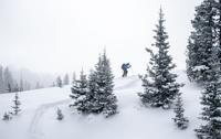
Snow falls around Brian Domonkos, the snow survey supervisor for the Natural Resources Conservation Service, as he treks into a SNOTEL site on Berthoud Pass on Thursday.
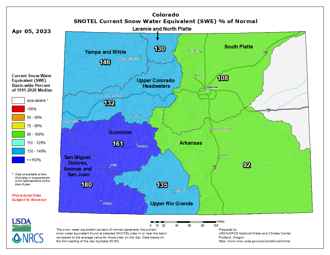
In some areas, the Western Slope has seen more than double the expected snow. An extreme example, Columbine Pass west of Montrose has seen 288% of expected snowpack, a SNOTEL shows. It is part of a basin in the southwest corner of the state that has seen 181% of normal snowpack, the highest across the state.
The Gunnison River Basin is the second highest with 161% of expected snowpack, NRCS numbers show. The Arkansas River basin is the only one that has not reached 100% of normal snowpack as of early April.
While about 20 of the 115 SNOTELS across Colorado were in record-setting territory for either a daily or all-time high Friday, Domonkos said, it is not an extreme year for the state.
“We have been in a drier period for the greater part of a decade and arguably longer than that,” he said. “So when we get these above normal years in our mind’s eye they definitely seem big.”
From across the Colorado basin, 10 million to 11 million acre-feet of runoff is predicted to flow into Lake Powell, helping to restore the lake that has dropped to historically low levels in recent years, said John Berggren, senior regional water policy analyst with Western Resource Advocates.
“It buys us months, maybe a year,” Berggren said, of the anticipated heavy flows. “It helps stave off the worst.”
Emergency releases not anticipated


Critically low levels at Lake Powell and Lake Mead could threaten hydropower production at the dams and have been at the center of a national discussion about the need to make major cuts to water use along the river after more than two decades of drought.
Not even several years of snowpack like this season could get the Colorado River out of the challenges it is facing, Berggren said. It could take up to eight years of above average snowpack to restore the system, and it is more likely this year is just a helpful bump of snow in a long-term trend of aridification, he said.
For example, a similar year in 2011 brought Lake Powell 16 million acre-feet of water, he said, a major boost to a reservoir with a capacity of about 25 million acre-feet. Storage was at 5.3 million acre-feet Friday, according to Bureau of Reclamation data.
With snow on its side for now, the Bureau of Reclamation is not expected to take emergency actions, such as releasing water from Colorado reservoirs to boost Lake Powell. But the agency’s analysis anticipated in coming weeks likely will repeat the call to reduce water use on the river, Berggren said.
The bureau is also expected to soon announce how much water will be released from Powell this year. With higher than expected inflows, the bureau is facing pressure to return to earlier operating guidelines and release up to 9 million acre-feet of water for the Lower Basin states, said Ken Curtis, the general manager for the Dolores Water Conservancy District in southwest Colorado. The release from Powell during the 2022 water year was only 7-MAF, by comparison.
“They are going to be put under pressure. Do you save some of this extra bounty or do you just use it and put yourself back into the same problem next year?” he said, describing the agency’s predicament.
Last year, the bureau asked the seven Colorado River Basin states to find a way to cut 2 million to 4 million acre-feet of water from their use. Since then, six of the states — Colorado, New Mexico, Nevada, Arizona, Utah and Wyoming — submitted a plan that would require California to take large cuts.
Arizona and Nevada could also see cuts, while other states would continue to make cuts based on drought conditions to ensure that enough water is sent downstream to meet their legal obligations.
California’s proposal requires Nevada and Arizona to take the major cuts.
Colorado Springs, Denver plan summer
As river users wait for the bureau’s decision, snowpack data is guiding short-term decisions for the coming summer for agriculture and cities such as Colorado Springs and Denver. The two communities are seeing about average snowpack in the basins they rely on, not the extraordinary numbers seen elsewhere.
Colorado Springs Utilities has an average amount of water in its reservoirs, and the snowpack could help Utilities staff sock away more water.
“When we boost our storage, that gives us more resilience and protects us a little bit from what might come next year,” said Kalsoum Abbasi, Utilities water conveyance planning supervisor.
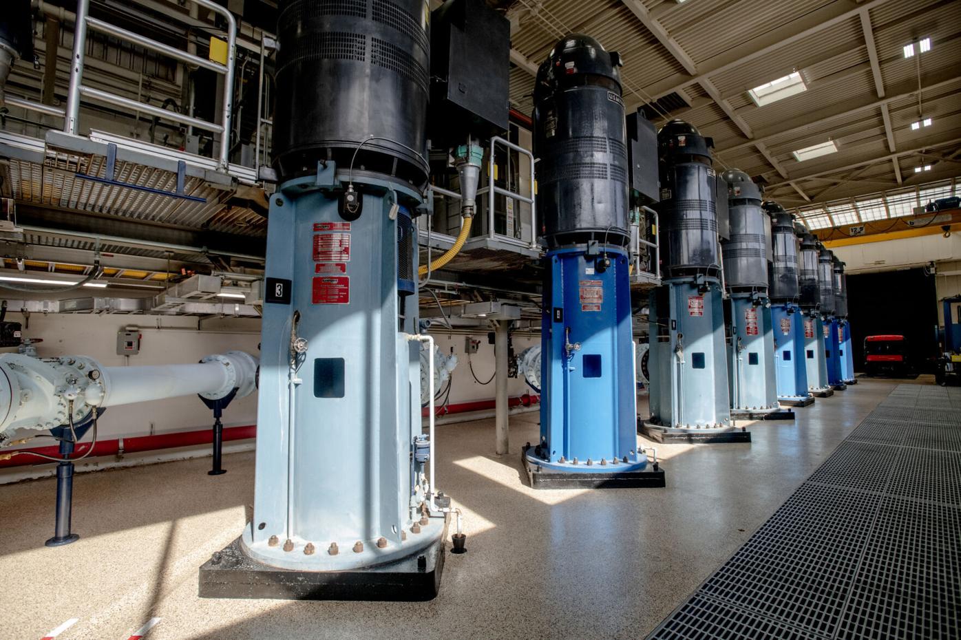
Otero Pump Station, pictured here, is one of five pump stations Colorado Springs Utilities uses to divert water from the western side of the Rocky Mountains for use in Colorado Springs.
Parker Seibold, The Gazette

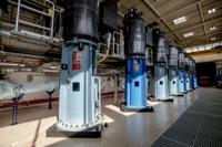
Otero Pump Station, pictured here, is one of five pump stations Colorado Springs Utilities uses to divert water from the western side of the Rocky Mountains for use in Colorado Springs.
A strong snowpack across the basin also helps ensure that Utilities can divert water for a longer period during the season, she said. The river is managed through a seniority system and when water runs short through the summer those with more junior rights such as Utilities are no longer allowed to divert water.
Colorado Springs saw near record-dry conditions in March, however, and the closest SNOTEL to town is reporting 14% of average snowpack, NRCS numbers show. Such dry conditions means residents could need more water to bring plants to life locally. But overall, Abbasi expects demands for outdoor irrigation in the city to stay steady, as they have in recent years.
Colorado Springs recently instituted new rules on lawns for new homes to encourage conservation, limiting the amount of grass irrigated with sprinklers to 25% of the yard.
Sampling Colorado Springs’ water
To help guide decisions, Colorado Springs Utilities and Denver Water staff take their own snow samples to determine how much water to expect in their reservoirs.
To get quality data, Utilities staff trek out in a slow-moving snowcat once a month to take samples above Homestake Reservoir northwest of Leadville. The reservoir is more than three hours by car from Colorado Springs and the staff live locally, not only to monitor the snow, but to maintain a complex system of reservoirs and pipelines that bring water hundreds of miles into town.
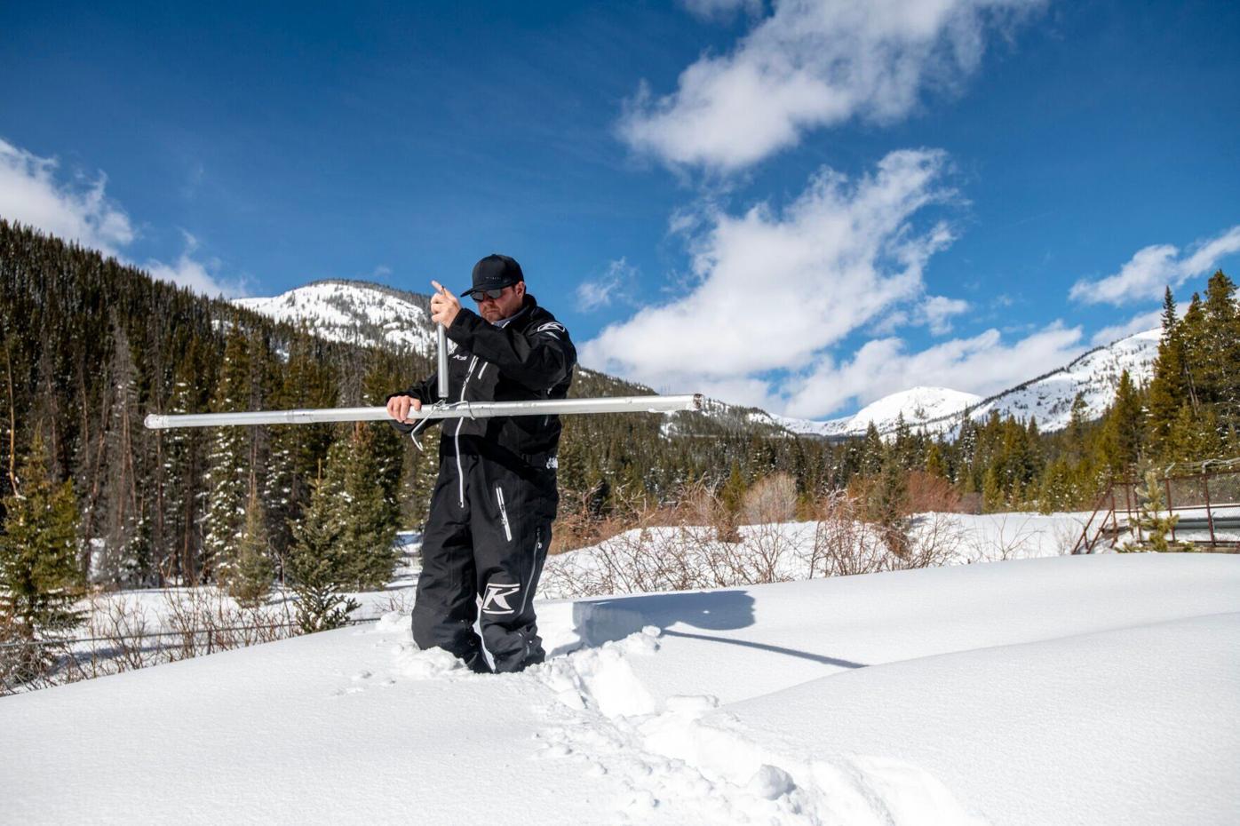
Colorado Springs Utilities employee Nick Miller demonstrates how their staff take their own samples of snow to determine how much water to expect in their reservoirs on March 14.
photos by Parker Seibold, The Gazette


Colorado Springs Utilities employee Nick Miller demonstrates how their staff take their own samples of snow to determine how much water to expect in their reservoirs on March 14.
Utilities employee Nick Miller demonstrated the process near Turquoise reservoir driving a long metal tube into the surface to take a core sample of snow and then weighing it to determine how much water it contains. A few feet away, water crashed through a diversion on its way down to Turquoise lake from Homestake.
In the Homestake Valley where the staff take samples, the snow averages around 50 inches and over the nine years that Miller has worked for utilities the levels stayed fairly stable, with high years reaching 75 inches of snow, he said.
While the Homestake area has not seen deficits in snowpack, Colorado Springs does not have senior rights to that water and so when the Colorado River Basin is in a dry season, Utilities must send water down Homestake Creek to farmers and other more senior users downstream.
During the coming spring runoff, Utilities staff will monitor the water via sensors on weirs at the bottom of five fishing ponds in the Homestake area that transmit data to satellites, he said.

The sun shines on snow near Turquoise Lake in Lake County on March 14. Although much of the west has seen above average snowfalls this year, it’s not enough to refill reservoirs like Lake Powell that have frequently experienced deficits over past two decades.
Parker Seibold, The Gazette

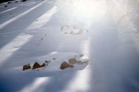
The sun shines on snow near Turquoise Lake in Lake County on March 14. Although much of the west has seen above average snowfalls this year, it’s not enough to refill reservoirs like Lake Powell that have frequently experienced deficits over past two decades.
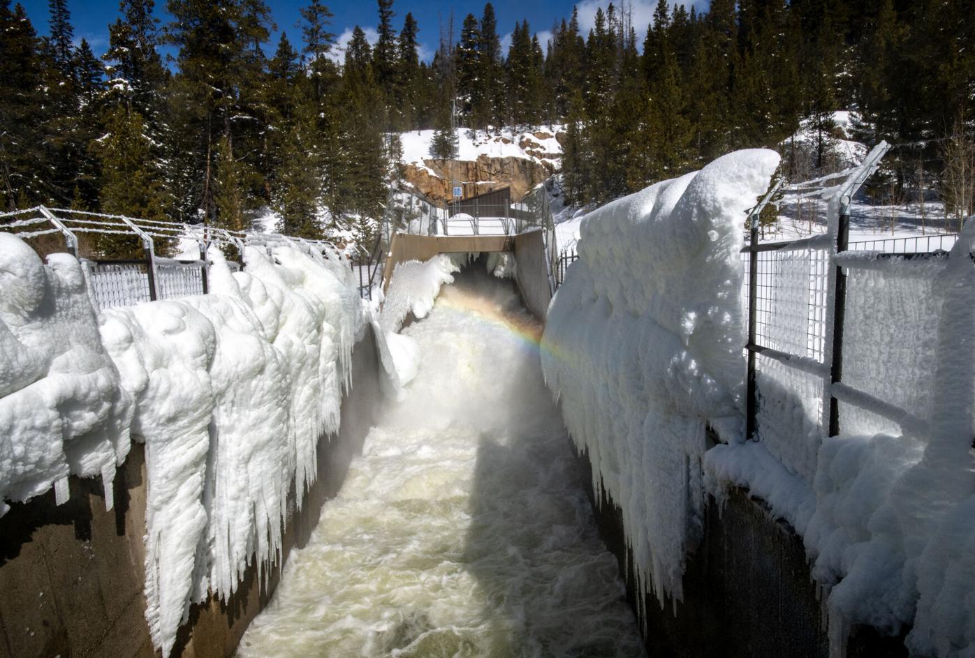
Water flows through the Homestake water diversion tunnel, feeding water into Turquoise Lake on March 14.
Parker Seibold, The Gazette


Water flows through the Homestake water diversion tunnel, feeding water into Turquoise Lake on March 14.
“The peaks are at midnight because the sun’s been beating on the snow all day,” Miller said. The low point is noon.
A rapid melt is bad news for Utilities because it can overflow the system, he said.
Colorado River water
Across the basin, SNOTEL data provides similar critical information by helping to build streamflow projections so that reservoir operators can manage lake levels.
This year, Colorado’s largest reservoirs, including Blue Mesa, are expected to recover, said Becky Bolinger, the assistant state climatologist.
In recent years, dry soils have soaked up runoff from fairly strong snowpack, but that is not expected to be as much of a problem this spring and will help ensure more water makes it to lakes and reservoirs, she said.
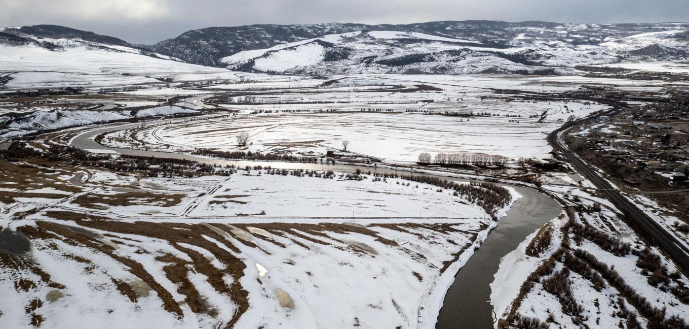
The Colorado River flows through Kremmling. As of Saturday, according to Natural Resources Conservation Service SNOTEL data, the Colorado headwaters region’s snow water equivalency is at 133%, tracking with above- average snowfalls throughout the Western Slope.
Parker Seibold, The Gazette

The Colorado River flows through Kremmling. As of Saturday, according to Natural Resources Conservation Service SNOTEL data, the Colorado headwaters region’s snow water equivalency is at 133%, tracking with above- average snowfalls throughout the Western Slope.
“Everything that feeds into the Colorado River basically is going to get a huge boost,” Bolinger said, describing conditions as “spectacular.”
She also is not expecting an early melt this year.
Such a simple statement, and other seemingly simple predictions, such as predicting literally how high the creeks might rise, is tricky work that relies on a huge number of variables.
“How dry is the air? What’s the relative humidity? How fast are the winds blowing? How strong is the sun? How much snowpack do we have? How quickly does the snowpack melt off? Air temperature? There is a lot of factors that go into it,” Domonkos said.
Those variables are collected by SNOTEL sites that send information mostly via satellites to inform computer models and determine the range of possibilities, he said.
Such data is getting ever more important as the Colorado River managers look to make big changes.
“You have to have good robust data. Otherwise what are you managing?” Berggren said.
He would like to see more SNOTEL sites added to the system at higher and lower elevations to create a more complete picture of the trends, he said.
Wet Western Slope
In the southwest corner of the state, where thousands of acres of farmland were fallowed in recent years, the stunning snowpack is set to bring fields back to life.
“(Farmers) are excited about the water and happy,” said Curtis, who manages McPhee Reservoir on the Dolores River.
Normally, irrigation would have started April 1, but it’s been delayed because runoff hasn’t started yet and snow is lingering at low elevations.
When the runoff starts, Curtis expects to fill the 381,195-acre-foot McPhee, provide full water allocations to area farmers, release water for rafting and store carryover for next year. The last time the lake filled was 2019, but this year the area has seen far more low elevation snow that has restored soil moistures.
“It’s pretty close to record-setting,” he said, of the snow season.
Contact the writer at mary.shinn@gazette.com or 719-429-9264.
Residents cite bike, pedestrian safety among top Vibrant Denver bond projects
Deborah Smith
deborah-smith@midtc.com
Updated 12 hours ago
1 of 2FILE PHOTO: Workers mark off a bike lane in downtown Denver. (Gazette file photo)Gazette file photo2 of 2Denver resident Katherine Jenkins speaks to the Denver City Council on Monday July 28 during a public hearing on Mayor Mike...
Deborah Smith
Reporter
DOJ files amended complaint against Colorado and Denver over sanctuary policies
Marianne Goodland
marianne-goodland@midtc.com
Updated 2 days ago
1 of 1Signage is seen at the headquarters of the United States Department of Justice (DOJ) in Washington, D.C., U.S., May 10, 2021. REUTERS/Andrew Kelly/File PhotoANDREW KELLY Facebook Twitter WhatsApp SMS Email Print Copy article link Save The U.S. Department...
Marianne Goodland
Reporter
Denver mayor pushes $15 million bump in bond funding for proposed American Indian Cultural Embassy
Deborah Smith
deborah-smith@midtc.com
Updated 2 days ago
1 of 1FILE PHOTO: Mayor Mike Johnston gives his annual 'State of the City' address to local leaders, press and Denver residents gathered at the Denver Center for the Performing Arts on Monday, July 21, 2025.Tom Hellauer/Denver Gazette Facebook Twitter...
Deborah Smith
Reporter
Controversial studies spark debate on safety of 7OH kratom
Marissa Ventrelli
marissa-ventrelli@midtc.com
Updated 2 weeks ago
1 of 1Yanawut / iStock Facebook Twitter WhatsApp SMS Email Print Copy article link Save Facebook Twitter WhatsApp SMS Email Print Copy article link Save Two studies examining the potential effects of a synthetic form of kratom have sparked excitement...
Marissa Ventrelli
Reporter
Colorado lawmakers call for pause on $60M Medicaid repayment that could impact 28 rural hospitals
Marissa Ventrelli
marissa-ventrelli@midtc.com
Updated 2 weeks ago
Facebook Twitter WhatsApp SMS Email Print Copy article link Save Facebook Twitter WhatsApp SMS Email Print Copy article link Save A bipartisan coalition of state lawmakers representing rural Colorado is calling on the state’s Medicaid agency to delay a $60...
Marissa Ventrelli
Reporter
Solar power and parking on July 14 Denver Council agenda
Deborah Smith
deborah-smith@midtc.com
Updated 2 weeks ago
1 of 1FILE PHOTO: Denver City and County building.Deborah Grigsby/Denver Gazette Facebook Twitter WhatsApp SMS Email Print Copy article link Save This week, the Denver City Council will consider three resolutions that amend on-call service agreements for photovoltaic generating facilities,...
Deborah Smith
Reporter
House Republican leader forwards allegations against Ron Weinberg to Legislative Legal Services
Marissa Ventrelli
marissa-ventrelli@midtc.com
Updated 3 weeks ago
Facebook Twitter WhatsApp SMS Email Print Copy article link Save A pair of letters from women accusing a Loveland legislator of making lewd comments has been sent to the Office of Legislative Workplace Relations, according to a House Republican leader. The...
Marissa Ventrelli
Reporter
Source: Johnston pushes merit-based layoffs as Denver faces $200 million deficit
Deborah Smith
deborah-smith@midtc.com
Updated 3 weeks ago
1 of 2FILE PHOTO: Denver Mayor Mike Johnston (AP Photo/David Zalubowski)David Zalubowski/Associated Press2 of 2Len Harris, Community Organizer with the American Federation of Labor and Congress of Industrial Organizations, stands with a group of union organizers on the steps of...
Deborah Smith
Reporter
Castle Rock’s building height limit proposal faces developer resistance
Noah Festenstein
noah-festenstein@midtc.com
Updated 2 weeks ago
1 of 2An aerial photo of downtown Castle Rock, Colorado. Town council postponed a proposal aimed to limit new developments to a maximum of four-stories.Courtesy photo, Town of Castle Rock2 of 2FILE PHOTO: Castle Rock town councilmembers (left to right)...
Noah Festenstein
Reporter
Adams County appoints interim county manager to permanent position
Kyla Pearce
kyla-pearce@midtc.com
Updated 3 weeks ago
1 of 1Dionne Stroter has been named the Adams County manager as of July 1. She had served as the interim manager.Courtesy photo, Adams County Facebook Twitter WhatsApp SMS Email Print Copy article link Save The Adams County Board of...
Kyla Pearce
Reporter