


Whiteout daily snow report, Dec. 29
Very little change to the forecast for Friday as Colorado sits under high pressure and storms are nowhere to be seen.
The mercury doesn’t appear to climb above 32 degrees however, with highs climbing toward the upper 20s and a continued low sun angle. This trend will continue through the weekend and into the new year.

A Weather.us forecast model shows the potential accumulation levels of water-equivalent precipitation as of 8 a.m. Monday, Jan. 1 for Colorado. Depending on the density of the snow, one inch of water is equivalent to 10 inches of snow based on a common rule of thumb ratio of 10:1.
Weather.us

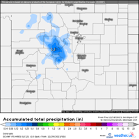
A Weather.us forecast model shows the potential accumulation levels of water-equivalent precipitation as of 8 a.m. Monday, Jan. 1 for Colorado. Depending on the density of the snow, one inch of water is equivalent to 10 inches of snow based on a common rule of thumb ratio of 10:1.
The ECMWF model has trickles of snow possible on Sunday and New Years Day, Monday for the north-central mountains (Copper, Cooper, Vail and Beaver Creek), but low accumulation amounts of less than 2 inches total by New Years Day sunset are about it.
The dry weather is forecast to stick around until around Jan. 4 or 5 when a storm grazes southern Colorado’s mountains. The storm track follows a line across northern New Mexico and could drop the majority of precipitation in Arizona and New Mexico, but snow showers appear to be more widespread south of I-70 for Jan. 5 morning.

A Weather.us forecast model shows the potential accumulation levels of water-equivalent precipitation as of 6 a.m. Friday, Jan. 5 for Colorado. Depending on the density of the snow, one inch of water is equivalent to 10 inches of snow based on a common rule of thumb ratio of 10:1.
Weather.us

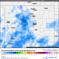
A Weather.us forecast model shows the potential accumulation levels of water-equivalent precipitation as of 6 a.m. Friday, Jan. 5 for Colorado. Depending on the density of the snow, one inch of water is equivalent to 10 inches of snow based on a common rule of thumb ratio of 10:1.
The forecast for after Jan. 5, however, appears to favor Colorado more. From Jan. 8 to 12, a storminess period should bring snow back in a couple of waves. More details to come as the forecast models align themselves.
Of note: On Dec. 29, 2006, a second of four storms to make its mark on the Front Range and urban corridor started dropping snow from the sky.
Denver residents were still digging out from the heavy snowfall and blizzard that occurred between Dec. 20-21, as the second major winter storm in a week buried the city and the eastern foothills again in more deep snow. Heavy snowfall ranged from 1-2.5 feet in the foothills and from 6-18 inches across the city. Another slow moving storm system centered over the Texas panhandle produced deep upslope flow over the high plains and against the Front Range Mountains.
In the foothills west of Denver, the snow fell at a rate of three to four inches an hour at times. Total snowfall in the foothills included: 30 inches near Genesee; 29.5 inches 12 miles northwest of Golden; 25 inches in Evergreen and near Bergen Park; 24 inches near Conifer; 23.5 inches 3 miles southwest of Golden and near Gold Hill; 23 inches near Jamestown; 22.5 inches in Rollinsville; 19.5 inches in Aspen Springs; 19 inches near Blackhawk; 18.5 inches at Nederland; 16 inches in Indian Hills, at Intercanyon, and in Eldora; 15.5 inches at Echo Lake; and 12 inches near Ralston Reservoir.
Today’s 24 hour snow total from Colorado resorts:
Arapahoe Basin – 0″
Aspen Mountain – 0″
Aspen Highlands – 0″
Beaver Creek – 0″
Breckenridge – 0″
Buttermilk – 0″
Cooper – 0″
Copper Mountain – 0″
Crested Butte – 0″
Echo Mountain – 0″
Eldora Mountain – 0″
Granby Ranch – 0″
Hesperus – Closed for season
Howelsen Hill – 0″
Kendall Mountain – 0″, open weekends
Keystone – 0″
Loveland – 0″
Monarch – 0″
Powderhorn – 0″
Purgatory – 0
Silverton – 0″
Snowmass – 0″
Steamboat – 0″
Sunlight – 0″
Telluride – 0″
Vail – 0″
Winter Park – 0″
Wolf Creek – 0″
Nederland to purchase Eldora Mountain Resort for upcoming season
Jonathan Ingraham
jonathan-ingraham@midtc.com
Updated 2 weeks ago
Facebook Twitter WhatsApp SMS Email Print Copy article link Save A lift at Eldora Mountain Resort. Photo Credit: Hoptocopter (iStock). Hoptocopter Skiers and riders now have an answer to the looming question: Who was to buy Eldora Mountain Resort outside Nederland,...
Jonathan Ingraham
Reporter
Kick off March’s warmth with Après skiing, fun and cheer | Whiteout
Jonathan Ingraham
jonathan-ingraham@midtc.com
Updated 2 weeks ago
1 of 1A man drinks a Long Drink cranberry alcoholic beverage a the top of Aspen Highlands resort in Aspen, Colorado.Courtesy, Pauli Kervinen/Long Drink Facebook Twitter WhatsApp SMS Email Print Copy article link Save March can be considered the “kick...
Jonathan Ingraham
Reporter
30-40″ of snow forecast for Colorado by mid month from four-storm punch as March starts
Jonathan Ingraham
jonathan-ingraham@midtc.com
Updated 2 weeks ago
1 of 1A skier finds the white room while skiing powder snow Saturday, Feb. 15, 2025 at Crested Butte Mountain Resort in Mount Crested Butte, Colorado.Courtesy, Taylor Ahearn/Crested Butte Mountain Resort Facebook Twitter WhatsApp SMS Email Print Copy article link...
Jonathan Ingraham
Reporter
3-5 feet of snow forecast in Colorado’s high country by Presidents’ Day weekend
Jonathan Ingraham
jonathan-ingraham@midtc.com
Updated 2 weeks ago
Facebook Twitter WhatsApp SMS Email Print Copy article link Save The snow machine pumping frosty flakes into Colorado’s high country continues into the second full week of February, with multiple feet forecast by Presidents’ Day weekend. Arctic cold will make...
Jonathan Ingraham
Reporter
‘Heavy snow’ inbound for Colorado during 10-day stormy period
Jonathan Ingraham
jonathan-ingraham@midtc.com
Updated 2 weeks ago
1 of 1A skier skis fresh powder snow Thursday, January 2, 2025 at Breckenridge Resort in Breckenridge, Colorado.Courtesy, JP Douvalakis, Breckenridge Ski Resort Facebook Twitter WhatsApp SMS Email Print Copy article link Save Facebook Twitter WhatsApp SMS Email Print Copy...
Jonathan Ingraham
Reporter
Leadville’s Skijoring event is coming, go be weird and watch | Whiteout
Jonathan Ingraham
jonathan-ingraham@midtc.com
Updated 2 weeks ago
Facebook Twitter WhatsApp SMS Email Print Copy article link Save Now that Groundhog Day has come and gone, the second half of winter is among us, which means all the weirdos start coming out of the wood work to do...
Jonathan Ingraham
Reporter
4-8 quick inches of snow forecast in Colorado for 2025’s first storm | Whiteout snow report
Jonathan Ingraham
jonathan-ingraham@midtc.com
Updated 4 weeks ago
Snow starts falling New Year’s Day afternoon and continues overnight, with a quick shot of between 2 and 8 inches for Colorado’s northern and central mountains. After bitter cold low temperatures on New Year’s Eve and New Year’s Day mornings,...
Jonathan Ingraham
Reporter
Mikaela Shiffrin can join the ‘100 Club’ with win 100 at Killington | Whiteout
Jonathan Ingraham
jonathan-ingraham@midtc.com
Updated 2 weeks ago
Facebook Twitter WhatsApp SMS Email Print Copy article link Save Mikaela Shiffrin has made the pilgrimage back to the United States ahead of Thanksgiving and should be set for this weekend’s ski races in Vermont. At Killington on Saturday and...
Jonathan Ingraham
Reporter
Newest ‘snow storm’ for Colorado to bring moderate totals: Whiteout daily snow report, April 30
Jonathan Ingraham
jonathan-ingraham@midtc.com
Updated 2 weeks ago
Facebook Twitter WhatsApp SMS Email Print Copy article link Save Winter’s last stand comes in the form of moderate snow showers from Wednesday night to Friday. Will skiers and riders at Colorado’s remaining open ski resorts get an early-May powder...
Jonathan Ingraham
Reporter
1-3 feet total from late-April snow storm in Colorado: Whiteout daily snow report, April 26
Jonathan Ingraham
jonathan-ingraham@midtc.com
Updated 2 weeks ago
Facebook Twitter WhatsApp SMS Email Print Copy article link Save Facebook Twitter WhatsApp SMS Email Print Copy article link Save Winter weather returned Thursday across Colorado’s high country and some snow fell. Within the next 48-hours, a prolonged snow event...
Jonathan Ingraham
Reporter