


It’s been a complicated era of recreation on Pikes Peak. Is a new era on the horizon?
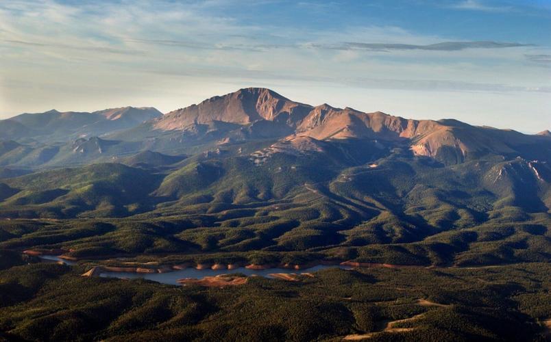
This aerial shot shows the north slope of Pikes Peak.
The Gazette File
One morning last week, Cory Sutela was driving from Colorado Springs to Denver to present a trail project seeking funds from Colorado Parks and Wildlife.
The trail, back in his home Pikes Peak region, had been built around a private development close to Pike National Forest.
“It’s less than a half-mile away from a Forest Service system trail,” Sutela explained. And to approve the connection, the Forest Service would need a review under the National Environmental Policy Act (NEPA) — a rather lengthy review and document considering any potential impacts to wildlife, vegetation, watersheds and cultural and historical aspects of the landscape.
Representing mountain biking nonprofit Medicine Wheel Trail Advocates, Sutela had identified a grant from Colorado Parks and Wildlife. His pitch, in short: “Can we do a NEPA? Because the Forest Service can’t.”
Colorado Springs parks champion retires, leaving much done and more to do
However small the trail in this case, the occasion underscored Sutela’s broader, long-going, often-contentious relationship with the Forest Service — and that of other such advocates around Pikes Peak. For many years, their interest in recreation has not seemed so aligned with the Forest Service.
“They are very concerned about any recreation even adjacent to the forest,” Sutela said.
He sympathizes.
Said another longtime advocate in Colorado Springs, Mike Rigney, who volunteers for Trails and Open Space Coalition: “The Forest Service, as I think everybody recognizes, is under-resourced.”
Potentially more so in 2025.
The agency entered the year facing steep budget cuts that would reportedly mean fewer seasonal employees and hard decisions on services and facilities. This is while the local Pikes Peak Ranger District, overseeing about 230,000 acres sprawling between El Paso and Teller counties, has been tasked with an unprecedented mandate for fire mitigation.
And this is while a major population grows at the foot of America’s Mountain. Along with that comes an increased need for law enforcement and environmental upkeep, advocates say. Also increasing: recreation desires.
“We’ve got this huge national forest, we’ve got this huge boundary next to three-quarters of a million people,” Sutela said. “The federal system isn’t set up to manage recreation for that, and it’s getting less and less able to.”
El Paso County Commissioner Stan VanderWerf has referred to vast “equities and encumbrances” across Pikes Peak. The situation “has been hampering us for decades,” the outdoorsman said at a meeting last month.
“For decades and decades we’ve been trying to improve access,” he said, “and it seems like we’re fighting for little tiny pieces, when I think the real issue is the strategic issue to the entire mountain.”
Sutela’s conclusion shared by others in the region: “We do need a new way of looking at responsible recreation management in the forest.”
An idea is gaining traction.
Utah ski patrollers reach deal with Vail Resorts to end strike; Is Colorado next?
‘A great next step’
Gov. Jared Polis recently announced his support for Colorado Parks and Wildlife “to improve and expand world-class recreation opportunities like camping, fishing, hiking and more” on Pikes Peak.
It was a bold statement concerning one of the state’s most iconic mountains, which might also be one of the most complex in terms of land management.
While largely owned by the Forest Service, the landscape is a patchwork of private and public interests — from the city of Colorado Springs enterprise that manages the Pikes Peak Highway, to The Broadmoor that runs the train up, to the business that operates the Summit House Visitor Center, to Colorado Springs Utilities that protects drinking water sources and to infrastructure of El Paso and Teller counties all in between.
Many of those agencies signed a letter of intent recently sent to Colorado Parks and Wildlife Director Jeff Davis.
The letter calls for “exploring a multi-jurisdictional collaborative solution” with CPW regarding Ring the Peak Trail, the unfinished loop around the mountain that has been decades in the making.
“Our shared intent will focus on balancing resiliency, safety, oversight, environmental conservation, watershed protection, recreation, operational need and other associated opportunities,” the letter reads.
The Forest Service referred to that language while declining comment for this story.
The letter of intent was “a great next step,” said Becky Leinweber. She’s executive director of nonprofit Pikes Peak Outdoor Recreation Alliance, which in recent years has convened land managers, advocates and outdoor industry people for far-reaching talks about the future of the landscape.
Colorado Springs Utilities has been central in those talks. Overseeing reservoirs with varying degrees of public access while also safeguarding other parts of the mountain, the agency declined an interview request.
Similar to the Forest Service, recreation advocates have often struggled over Utilities’ priorities. Leinweber called the potential collaboration with CPW “a win-win” for Utilities.
“It allows them to better focus on what their mission is, while ensuring the public can enjoy spaces that rest on (Utilities) property,” Leinweber said. “But, of course, we have to be very careful about where those areas are. What can be further developed, we have yet to see.”
New trails, open space plans, quarry reclamation: Colorado Springs parks goals for 2025
Another round in the Ring?
Specifics are yet undetermined. One seemingly shared interest: the Ring the Peak corridor.
From a vision dating back to the 1990s, the corridor covers 60-plus miles of trail from Colorado Springs, wrapping around to Pikes Peak’s backside in Teller County. There, near Cripple Creek and Victor, various individuals have long toiled over Ring the Peak’s final gaps.
That includes Rigney, who in more recent years led efforts on behalf of Trails and Open Space Coalition. Buoyed by then-Gov. John Hickenlooper’s call to action in 2016 — he proclaimed Ring the Peak a future international destination as part of his “16 in ‘16” initiative — Rigney and a team embarked on deep analysis and hosted several meetings in Teller County.
“Everywhere we turned, we ran into insurmountable roadblocks,” he said.
They found bighorn sheep habitat preventing a trail higher up. A lower trail was blocked by Cripple Creek and Victor officials protecting drinking water sources. Another proposed route dealt with a web of private, state and federal lands.
Steve Bremner, with advocacy group Friends of the Peak, wished CPW luck: “I’m perfectly happy with them beating their head against the wall like we did out there in Cripple Creek and Victor.”
But the prospective CPW collaboration should not be about completing Ring the Peak, said Teller County Commissioner Dan Williams. At least not right away.
“I wouldn’t want to complete anything and then find out we’re in trouble,” he said from his home near Cripple Creek.
Trouble has been the local fear over Ring the Peak, what Williams said has been “a dirty word” among fellow residents.
“There has always been a strong push from outdoor enthusiasts, and that’s right and proper,” Williams said. “What has been missing is that voice saying, ‘Wait a minute, let’s talk about the impacts here.’”
Who would be paying for the trail and maintenance? he asked. Where might backpackers camp, and who would be tending to campsites and fire rings? Could a devastating fire be prevented? Who responds to other emergencies? What about law enforcement? “What happens to the animals up there?” Williams added. “What’s the impact on that?”
Maybe, he said, CPW is the answer.
In signing the letter of intent committing to more dialogue with the agency, Williams recognized those concerns and threats already existing across Teller County, surrounded by Pike National Forest. “Currently it’s organized chaos,” Williams said.
“So doing nothing is not an option,” he said. “And doing it by ourselves is not an option, because we don’t have the budget to support it.”
Perhaps CPW does, said Trails and Open Space Coalition Executive Director Glenn Carlson.
He mentioned high hopes over the Keep Colorado Wild Pass, which serves as additional revenue for the agency and as a state parks pass for drivers who opt to pay $29 every year when registering their vehicle. From the pass’s first year in 2023, CPW reportedly generated nearly $40 million.
Just as important as funding, CPW could provide “continuity” to the Ring the Peak effort, Carlson said: “This is the type of project that will outlast most people and positions. And so to have somebody like CPW that has a kind of staying power to continue to work on this, I think that’s probably the most critical positive that we get out of this partnership.”
Remembering Luke: New Year’s Eve fireworks on Pikes Peak will honor AdAmAn’s first posthumous member
Routes still undecided
What does that partnership look like?
CPW has offered the example of the Arkansas Headwaters Recreation Area. CPW oversees trails, camping, fishing and more along 152 miles of the Arkansas River — along terrain largely owned by the Bureau of Land Management.
CPW runs Lake Pueblo State Park on Bureau of Reclamation property. Trinidad Lake State Park sits on U.S. Army Corps of Engineers property. And closer by, Cheyenne Mountain State Park was developed on city of Colorado Springs-owned land.
“We’re used to working with partners and different land management agencies,” said Frank McGee, CPW’s local regional manager. “What makes (Pikes Peak) a little more complicated is the number of partners.”
First and foremost is the largest landowner. The Forest Service signing the letter of intent to CPW signaled a shift, said Rigney, who recalled early meetings on the potential collaboration.
The Forest Service’s initial reaction was “pretty negative,” Rigney said. “I think it’s become a lot better in the last few months. They were pretty defensive about their role in the region.”
As they should be, said Sutela with Medicine Wheel Trail Advocates.
“There are very well-defined constraints that the Forest Service have,” he said. “And we certainly don’t want to start getting rid of the protections the Forest Service has for the natural places we care about.”
But Sutela has insisted that well-managed recreation can be a form of conservation. He considered the Forest Service’s dilemma with damaging “social trails” carved over the years.
Other than reroutes, “I can’t think of a single new section of trail that has gone through a federal process on the national forest in the 20 years that I’ve been here,” Sutela said.
“And I think user-built trails that we keep seeing are a result of that. People are not only befuddled by the complicated process (of the Forest Service), but even the Forest Service isn’t able to support that process and actually initiate it. And so people get fed up and build their own trails.”
Bremner and others have imagined several summit paths up Pikes Peak, more than just Barr Trail and the backside route via Devil’s Playground. “Ring the Peak would be the circular trail, and we’d have spokes leading to the summit all around the mountain,” Bremner said.
But such interest has equal pushback. “More scars upon the land,” read one response to land managers’ letter of intent posted on social media. “When these folks tell us it’s ‘sustainable recreation’ that means it’s a park that you pay to enter.”
CPW’s model indeed depends on passes and fees. And some expanded role for the agency indeed poses possible changes to lands as Teller County locals have known them, Williams recognized. (He sits on CPW’s partnering Colorado Wildlife Council.)
He noted nearby Dome Rock State Wildlife Area, open only to visitors with a hunting or fishing license.
“I can’t tell you how many people have called to complain: ‘Whose right is it to charge to walk on public land?’” Williams said. “So the ‘pay to play’ will have to be on message. The pushback will be, Why? And what am I getting for it?”
For now, there are more questions than answers. “We have to sort of lay out the chess table,” Williams said.
Get OutThere
Signup today for free and be the first to get notified on new updates.
Fallen climber rescued in Eldorado Canyon State Park south of Boulder Wednesday
Jonathan Ingraham
jonathan-ingraham@midtc.com
Updated 6 days ago
Facebook Twitter WhatsApp SMS Email Print Copy article link Save A climber was rescued from the Red Garden Wall and Yellow Spur climbing area in Boulder County inside Eldorado Canyon State Park on Wednesday, July 30, 2025. Courtesy, Boulder County...
Jonathan Ingraham
Reporter
1 dead after 150-foot fall from steep rock face in Jefferson County
Daniel Boniface
daniel-boniface@midtc.com
Updated 2 weeks ago
1 of 1Crews gather for a recovery effort after one person died after falling about 150 feet near Conifer on Thursday, July 24, 2025.Provided by the Elk Creek Fire Department Facebook Twitter WhatsApp SMS Email Print Copy article link Save...
Daniel Boniface
Reporter
Trails expanding at Colorado’s newest state park
Seth Boster
seth-boster@midtc.com
Updated 2 weeks ago
1 of 1Three hikers make their way up Upper Lone Cub Trail at Fishers Peak State Park.gazette file Facebook Twitter WhatsApp SMS Email Print Copy article link Save The possibilities for adventure are growing around one of southern Colorado’s most...
Seth Boster
Reporter
Guanella Pass leaf peeping traffic could ease thanks to this change
Jonathan Ingraham
jonathan-ingraham@midtc.com
Updated 2 weeks ago
1 of 1FILE PHOTO: The Clear Creek County Sheriff's Office will begin ticketing motorists who park in the "No Parking" zones on Guanella Pass, officials announced on social media Wednesday. (Photo courtesy of Clear Creek County)Courtesy photo, Clear Creek County...
Jonathan Ingraham
Reporter
Colorado ski resort fights mountain beetle infestation with this unique substance
Jonathan Ingraham
jonathan-ingraham@midtc.com
Updated 2 weeks ago
Facebook Twitter WhatsApp SMS Email Print Copy article link Save A forest maintenance workers staples a verbenone pheromone packet to a tree during a mountain pine beetle beetle kill mitigation project Monday, June 30, 2025 at Crested Butte Mountain Resort...
Jonathan Ingraham
Reporter
Douglas County cans idea to allow ‘minimalist camping’ at Sandstone Ranch
Noah Festenstein
noah-festenstein@midtc.com
Updated 2 weeks ago
1 of 1FILE PHOTO: Afternoon clouds rollover some of the redrock formations Thursday, June 20, 2018, at the 2,038-acre Sandstone Ranch outside Larkspur , Colo. (The Gazette, Christian Murdock)Christian Murdock/The Gazette Facebook Twitter WhatsApp SMS Email Print Copy article link...
Noah Festenstein
Reporter
Alt-rock: Why some jam to the less-traveled, extreme sides of Colorado 14ers
Seth Boster
seth-boster@midtc.com
Updated 2 weeks ago
1 of 4Colorado Fourteeners Initiative in recent years has rerouted a section of Black Cloud Trail on Mount Elbert — part of an alternate route the nonprofit’s executive director, Lloyd Athearn, recommends for those looking to get off standard trails...
Seth Boster
Reporter
Funding approved for controversial Mad Rabbit trails in Colorado
Seth Boster
seth-boster@midtc.com
Updated 3 weeks ago
1 of 1A cyclist crosses over boulders beside Fish Hook Lake on Rabbit Ears Pass.Courtesy of Lucy Winslow, Routt County Riders Facebook Twitter WhatsApp SMS Email Print Copy article link Save Funding has been approved for a major, controversial project...
Seth Boster
Reporter
Colorado endurance runner Anne Flower talks running experience after Silver Rush 50 win
Jonathan Ingraham
jonathan-ingraham@midtc.com
Updated 2 weeks ago
Facebook Twitter WhatsApp SMS Email Print Copy article link Save Anne Flower crosses the finish line in first place Sunday, July 13, 2025 at the Life Time Silver Rush 50 Run endurance race in Leadville, Colorado. Courtesy, Leadville Race Series...
Jonathan Ingraham
Reporter
Inside an ancient place of intrigue east of Colorado Springs
Seth Boster
seth-boster@midtc.com
Updated 2 weeks ago
1 of 4Pikes Peak looms in view from Corral Bluffs Open Space.photos courtesy of City of Colorado Springs2 of 4Ranger Mike Bowman shows visitors around Corral Bluffs Open Space on the eastern edge of Colorado Springs. Gazette photo3 of 4Ian...
Seth Boster
Reporter