


New addition coming to long-dreamed trail west of Colorado Springs
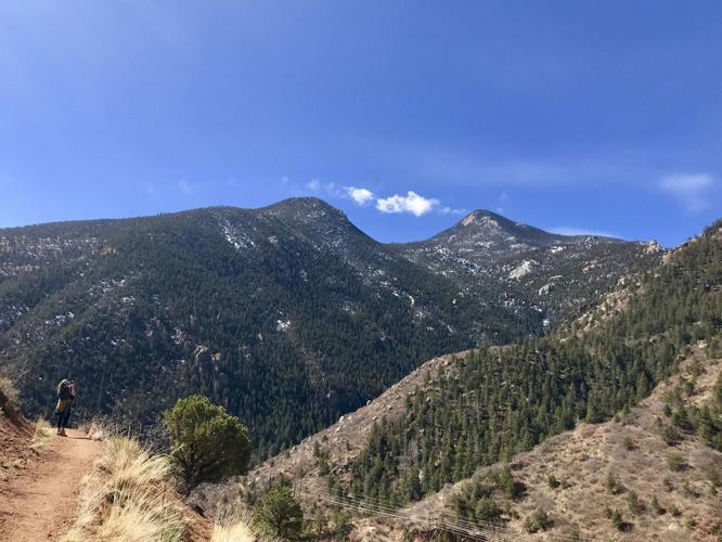
Cameron’s Cone and the mountains around Manitou Springs are seen from a section of Ute Pass Regional Trail.
Seth Boster, The Gazette
El Paso County is moving ahead on a long-dreamed trail touring the hills west of Colorado Springs.
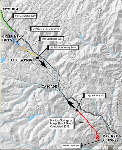
Ute Pass Regional Trail has been more than a decade in the making, predating a master plan published in 2015. The plan maps the 11-mile trail running from Manitou Springs up through Cascade and Green Mountain Falls, ending around Crystola near the Teller County line.
Small parts of Ute Pass Regional Trail have been added since 2003 — mostly toward the far west boundaries, opposite the trailhead beside the Manitou Incline. From the Incline base, the trail starts about 3 miles up to a turnaround, where panels are posted recalling the historic route used by the Ute people.
A gap has existed westward to the Cascade-Chipita Park area. Part of that gap could be filled later this year.
A 1.5-mile segment is set for construction under the El Paso County parks department’s capital improvement program for 2025. The segment will stretch from Winnemucca Road in Cascade-Chipita Park, following Chipita Park Road down to Spring Street in Cascade, where a trailhead is planned with parking and restrooms.
The idea is something of a commuter path — an alternative route on foot or bike roughly following the Ute Pass stretch of U.S. 24.
“I think we’re all excited to get this project going again, to get boots on the ground again,” said Jason Meyer, overseeing the project for El Paso County.
Ute Pass Regional Trail hasn’t seen development since 2020. That’s when a section was finished from Ute Pass Elementary down to Winnemucca Road. Previously, a section was built from the trail’s western terminus around Crystola down through Green Mountain Falls to the school.
“We’re trying to work our way back down into Manitou Springs,” Meyer said.
That has been complicated. Design for the upcoming 1.5-mile segment has been in the works since 2019, Meyer said.
“It’s a narrow stretch of right-of-ways, there’s a lot of utilities conflicts to work through and drainage that we obviously have to account for,” he said. “So it’s just been a really long, thoughtful design process.”
Once complete, he said, a little more than a mile will be left to finish the full 11-mile vision — from Spring Street in Cascade tying into the trail out of Manitou.
“That’s gonna be our most challenging piece,” Meyer said, explaining more right-of-ways along U.S. 24, pedestrian bridges over Fountain Creek and agreements with Colorado Springs Utilities. “That’s why we’ve been kind of waiting to do everything but that one.”
He was eager for the upcoming addition to “refocus” the project. “It kinda gets it back on people’s radars and helps with momentum on getting this last piece done.”
The next 1.5 miles will be paved, matching stretches through Cascade and Green Mountain Falls. (The trail from Manitou is the only dirt stretch.)
“It’s gonna have recreational value, but there’s another layer to it, which is providing a safe, pedestrian corridor for anyone living in those communities,” Meyer said. “It’ll be like a commuter route, in addition to those people who come to recreate and want that challenge” of an 11-mile trail.
The significance goes beyond that, he said.
Ute Pass Regional Trail is part of Ring the Peak Trail, the loop envisioned for the circumference of Pikes Peak that has been many more years in the making. And Meyer pointed to the 1912 dedication of the historic Ute trail out of Manitou.
“It’s very unique, the historic and cultural significance of it — to be able to walk in the same footsteps of the Ute Tribe,” Meyer said. “I think it’s pretty significant to keep that and honor it.”
The 1.5-mile trail construction could gain final approvals “in the next couple of months,” he said. The county will then put the job out to bid, with hopes of finishing by the end of the year.
The project is being funded through the Federal Highway Administration’s Transportation Alternatives and Transportation Improvement programs.
Fallen climber rescued in Eldorado Canyon State Park south of Boulder Wednesday
Jonathan Ingraham
jonathan-ingraham@midtc.com
Updated 5 days ago
Facebook Twitter WhatsApp SMS Email Print Copy article link Save A climber was rescued from the Red Garden Wall and Yellow Spur climbing area in Boulder County inside Eldorado Canyon State Park on Wednesday, July 30, 2025. Courtesy, Boulder County...
Jonathan Ingraham
Reporter
1 dead after 150-foot fall from steep rock face in Jefferson County
Daniel Boniface
daniel-boniface@midtc.com
Updated 1 week ago
1 of 1Crews gather for a recovery effort after one person died after falling about 150 feet near Conifer on Thursday, July 24, 2025.Provided by the Elk Creek Fire Department Facebook Twitter WhatsApp SMS Email Print Copy article link Save...
Daniel Boniface
Reporter
Trails expanding at Colorado’s newest state park
Seth Boster
seth-boster@midtc.com
Updated 2 weeks ago
1 of 1Three hikers make their way up Upper Lone Cub Trail at Fishers Peak State Park.gazette file Facebook Twitter WhatsApp SMS Email Print Copy article link Save The possibilities for adventure are growing around one of southern Colorado’s most...
Seth Boster
Reporter
Guanella Pass leaf peeping traffic could ease thanks to this change
Jonathan Ingraham
jonathan-ingraham@midtc.com
Updated 2 weeks ago
1 of 1FILE PHOTO: The Clear Creek County Sheriff's Office will begin ticketing motorists who park in the "No Parking" zones on Guanella Pass, officials announced on social media Wednesday. (Photo courtesy of Clear Creek County)Courtesy photo, Clear Creek County...
Jonathan Ingraham
Reporter
Colorado ski resort fights mountain beetle infestation with this unique substance
Jonathan Ingraham
jonathan-ingraham@midtc.com
Updated 2 weeks ago
Facebook Twitter WhatsApp SMS Email Print Copy article link Save A forest maintenance workers staples a verbenone pheromone packet to a tree during a mountain pine beetle beetle kill mitigation project Monday, June 30, 2025 at Crested Butte Mountain Resort...
Jonathan Ingraham
Reporter
Douglas County cans idea to allow ‘minimalist camping’ at Sandstone Ranch
Noah Festenstein
noah-festenstein@midtc.com
Updated 2 weeks ago
1 of 1FILE PHOTO: Afternoon clouds rollover some of the redrock formations Thursday, June 20, 2018, at the 2,038-acre Sandstone Ranch outside Larkspur , Colo. (The Gazette, Christian Murdock)Christian Murdock/The Gazette Facebook Twitter WhatsApp SMS Email Print Copy article link...
Noah Festenstein
Reporter
Alt-rock: Why some jam to the less-traveled, extreme sides of Colorado 14ers
Seth Boster
seth-boster@midtc.com
Updated 2 weeks ago
1 of 4Colorado Fourteeners Initiative in recent years has rerouted a section of Black Cloud Trail on Mount Elbert — part of an alternate route the nonprofit’s executive director, Lloyd Athearn, recommends for those looking to get off standard trails...
Seth Boster
Reporter
Funding approved for controversial Mad Rabbit trails in Colorado
Seth Boster
seth-boster@midtc.com
Updated 3 weeks ago
1 of 1A cyclist crosses over boulders beside Fish Hook Lake on Rabbit Ears Pass.Courtesy of Lucy Winslow, Routt County Riders Facebook Twitter WhatsApp SMS Email Print Copy article link Save Funding has been approved for a major, controversial project...
Seth Boster
Reporter
Colorado endurance runner Anne Flower talks running experience after Silver Rush 50 win
Jonathan Ingraham
jonathan-ingraham@midtc.com
Updated 2 weeks ago
Facebook Twitter WhatsApp SMS Email Print Copy article link Save Anne Flower crosses the finish line in first place Sunday, July 13, 2025 at the Life Time Silver Rush 50 Run endurance race in Leadville, Colorado. Courtesy, Leadville Race Series...
Jonathan Ingraham
Reporter
Inside an ancient place of intrigue east of Colorado Springs
Seth Boster
seth-boster@midtc.com
Updated 2 weeks ago
1 of 4Pikes Peak looms in view from Corral Bluffs Open Space.photos courtesy of City of Colorado Springs2 of 4Ranger Mike Bowman shows visitors around Corral Bluffs Open Space on the eastern edge of Colorado Springs. Gazette photo3 of 4Ian...
Seth Boster
Reporter