


Summiting Colorado’s most popular 14er in the least popular (and more technical) way
QSB2aWV3IGludG8gdGhlIHZhbGxleSBiZWxvdyBRdWFuZGFyeSBQZWFrLCB0b3dhcmQgQmx1ZSBMYWtlcy4gUGhvdG8gQ3JlZGl0OiBTcGVuY2VyIE1jS2VlLg==
If someone is into fourteener-bagging in Colorado, there’s a good chance they’ve already summited Quandary Peak. More than 20,000 people summit the peak each year, with almost every hiker climbing up and down the standard class one ‘east ridge’ route.
Given the ample number of people on the trail and parking rules that have popped up in recent years, Quandary tends to be a mountain many seasoned hikers avoid – an overcrowded, uphill trudge offering little chance of a true escape into nature. That being said, there’s more than one way to climb this mountain and reaching the top via a non-standard option allows experienced climbers to miss the hordes almost entirely.
Author’s Note: The route I’m about to describe requires quite a bit of route-finding and features lots of exposure. A simple mistake can lead to getting lost in a dangerous spot on this route. Hikers are regularly rescued from this route and it’s easy to see why. DO NOT attempt this route if underprepared or inexperienced. Extensive research and training is needed prior to embarking on this climb – and that means a lot more than just reading this article. And yes, there are several ways to get to the top of this peak – this route is one of the least traveled.
Outside of the standard East Ridge route, there are three other official ways to summit Quandary Peak – the West Ridge, the Quandary Couloir, and the Cristo Couloir. Both the Quandary Couloir and the Cristo Couloir are considered snow routes (when avalanche risk isn’t too high) and should be reserved for those conditions for safety reasons, leaving only the West Ridge as an official summer alternative to the crowded East Ridge route.
Rated as class three, the West Ridge route requires that climbers navigate an exposed and dangerous ridge that features loose rock and big drops. It’s a major change of pace from the dirt trail that leads most to the top of the peak, covering three hard miles on the way up the mountain during an ascent of about 2,650 feet.
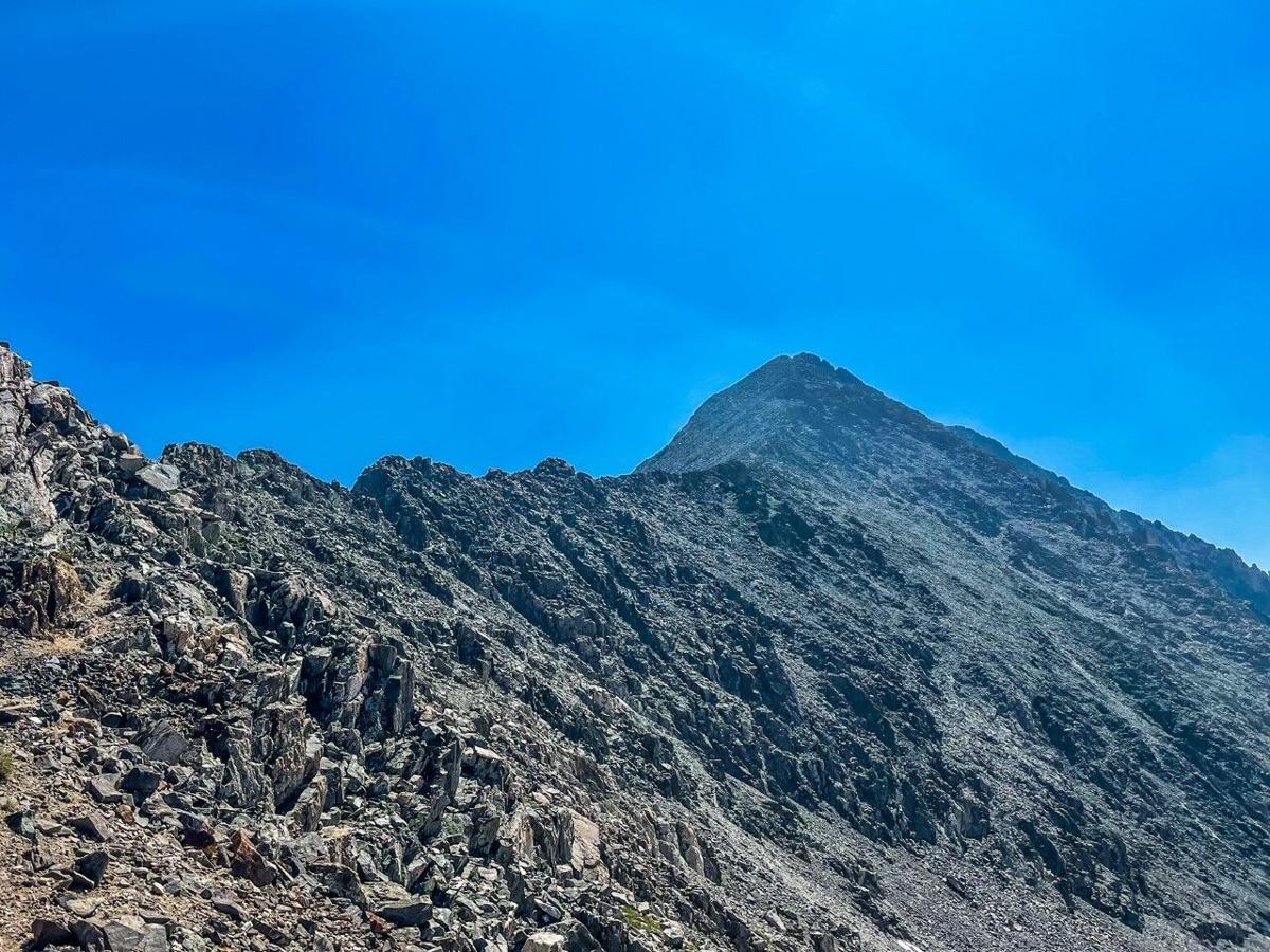
The West Ridge of Quandary Peak, outside of Breckenridge, Colorado. Photo Credit: Spencer McKee.

The West Ridge of Quandary Peak, outside of Breckenridge, Colorado. Photo Credit: Spencer McKee.
The West Ridge route starts at the upper lake of the Blue Lakes on Blue Lakes Road, just off of Hoosier Pass and about two miles up the road from the standard East Ridge trailhead. Skirting the northern side of the lake before ascending into a green valley, the start of this route delivers great views of surrounding mountains and a serene setting.
Through this portion of the route, the trail is fairly easy to follow provided one is good at spotting sparse cairns and has a general knowledge of where they’re headed. A common mistake made here is attempting to ascend to the western ridge of Quandary too quickly, while the correct route first takes hikers to the saddle between Quandary Peak and Fletcher Mountain.
Once the aforementioned saddle is gained, the trail quickly gets significantly trickier.
At this point, hikers start their ascent up the west ridge of Quandary Peak. At first, the route is lightly-trodden difficult class two. Route-finding can immediately pose a problem if one is not careful and familiar with where they’re headed. While it’s obvious that taking the ridge to the summit is the goal, getting off-course is very possible and can leave hikers in unstable rock fields or in loose, cliffside terrain. Don’t count as cairns, as they seem to be few and far between, often blending into the surrounding landscape.
The class two approach toward the summit is consistent in gain and can be traveled at a moderate pace if one knows where they’re headed. Don’t be fooled though – the most difficult portion of this route takes place during the final moments of the climb.
As hikers continue along the ridge, those on the distant summit get closer and closer, eventually near enough to probably hear a loud shout. At this point, the class three climbing starts.
The first difficult wall to ascend has decent holds. A few stem moves allow trailgoers to surpass the obstacle with relative ease, though consequences of a fall could be dire. I found that my rock climbing experience helped a lot here, with the climb feeling very natural.
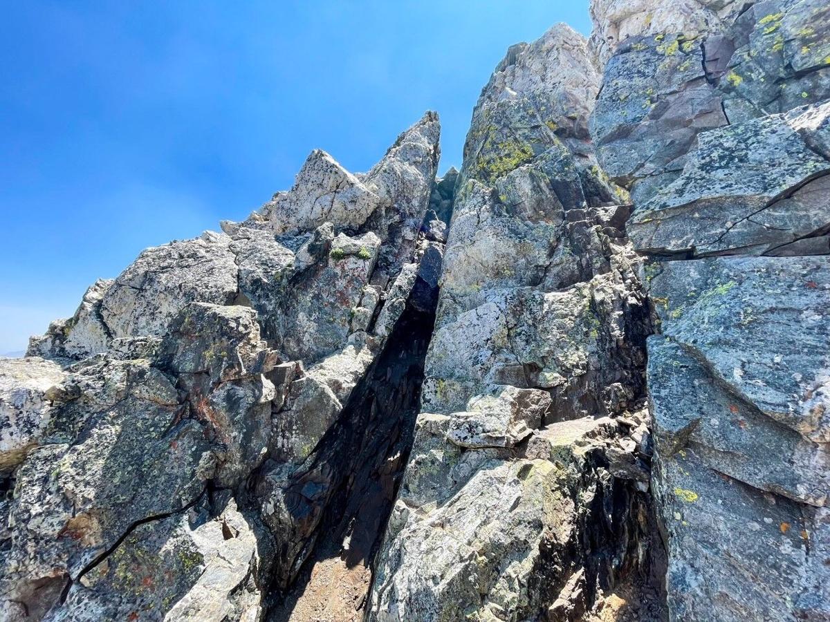
The first major obstacle on the Quandary West Ridge route. Photo Credit: Spencer McKee.

The first major obstacle on the Quandary West Ridge route. Photo Credit: Spencer McKee.
Once this wall is gained, the final crux wall is revealed – a similar near-vertical climb with about twice the height. After a careful downclimb, the base of this crux wall is reached.
The crux of the west ridge route up Quandary Peak. Note the goat at the top of the route for scale. Also zoom to see climbers on the summit in the distance. Photo Credit: Spencer McKee.

The crux of the west ridge route up Quandary Peak. Note the goat at the top of the route for scale. Also zoom to see climbers on the summit in the distance. Photo Credit: Spencer McKee.
The first few moves feel a lot like climbing up a natural staircase with a few more difficult movements to follow. This is another class three section that should feel very natural for those used to climbing on real rock that are also comfortable unroped and exposed.
Once the top of the crux wall is reached, a short five-minute walk to the summit is all that’s left.
Spencer McKee approaches the summit along the west ridge of Quandary Peak.

Spencer McKee approaches the summit along the west ridge of Quandary Peak.
From the summit, epic views can be enjoyed in every direction.
It’s recommended that those coming down from the mountain that have ascended via the West Ridge use the East Ridge route to descend. I ran down the East Ridge, tacking on around 5.5 miles to get back to the Blue Lakes Trailhead.
Overall, I found the West Ridge route to the summit of Quandary Peak to be a blast. It offers fun class three climbing that’s backdropped by a beautiful scene, with a loop that can take four to six hours for those capable of moving quickly. That being said, this route does require extensive route-finding and does feature exposure that could kill. The level of commitment is also high, with turning around likely difficult at times. Proceed with extreme caution.
Author’s Note: Due to the high level of commitment on this route, being aware of the weather is crucial. Do not climb this route if there is a risk of stormy weather. It’s also recommended that hikers use a GPS communication device, such as a Garmin inReach.
STAY INFORMED: Get free Colorado news with our daily newsletter (Click here)
Here are 5 places where you can see fireflies in Colorado
Spencer McKee
spencer-mckee@midtc.com
Updated 17 hours ago
1 of 1RmlyZWZsaWVzIGluIHRoZSB3b29kcy4gUGhvdG86wqBMQm9jaGV2IChpU3RvY2spLg==TEJvY2hldg== Facebook Twitter WhatsApp SMS Email Print Copy article link Save $(window).load(function() { window.setTimeout(affixShare, 2000); function affixShare() { var sHeight = $(‘#share-left-affix’).outerHeight(true); var cHeight = $(‘#share-left-affix’).parent().outerHeight(true); var sTop = $(‘#share-left-affix’).offset().top – 100; var sBottom = $(document).height() – ($(‘#share-left-affix’).parent().offset().top...
Spencer McKee
Reporter
Birria burrito at 4.9-star Colorado Springs restaurant may be the best around
Spencer McKee
spencer-mckee@midtc.com
Updated 17 hours ago
1 of 1VGhlIEJpcnJpYS1CdXJybyBhdCBQb3IgRmF2b3IgVGFjb3MgYW5kIFRyYWdvcy4gUGhvdG86IFNwZW5jZXIgTWNLZWUuU3BlbmNlciBNY0tlZQ== Facebook Twitter WhatsApp SMS Email Print Copy article link Save $(window).load(function() { window.setTimeout(affixShare, 2000); function affixShare() { var sHeight = $(‘#share-left-affix’).outerHeight(true); var cHeight = $(‘#share-left-affix’).parent().outerHeight(true); var sTop = $(‘#share-left-affix’).offset().top – 100; var sBottom = $(document).height() – ($(‘#share-left-affix’).parent().offset().top...
Spencer McKee
Reporter
The five-day ‘water-bound’ road trip around Colorado
Piper Russell
piper-russell@midtc.com
Updated 3 days ago
1 of 1UGhvdG86wqBBem1hbkpha2EgKGlTdG9jaykuQXptYW5KYWth Facebook Twitter WhatsApp SMS Email Print Copy article link Save $(window).load(function() { window.setTimeout(affixShare, 2000); function affixShare() { var sHeight = $(‘#share-left-affix’).outerHeight(true); var cHeight = $(‘#share-left-affix’).parent().outerHeight(true); var sTop = $(‘#share-left-affix’).offset().top – 100; var sBottom = $(document).height() – ($(‘#share-left-affix’).parent().offset().top...
Piper Russell
Reporter
The perfect one-day mountain-bound road trip around Colorado
Spencer McKee
spencer-mckee@midtc.com
Updated 4 days ago
1 of 1SGVyZSdzIGEgbG9vayBhdCB0aGUgb25lLWRheSByb2FkIHRyaXAuIE1hcDogwqkyMDI1IEdvb2dsZSBNYXBzOyBHYXJkZW4gb2YgdGhlIEdvZHMgaW1hZ2UgKGJvdHRvbSByaWdodCk6IFdpcmVzdG9jayAoaVN0b2NrKTsgU291dGggUGFyayBDaXR5IGltYWdlIChib3R0b20gbGVmdCk6IGNoYXBpbjMxIChpU3RvY2spOyBCcmVja2VucmlkZ2UgaW1hZ2UgKHRvcCBsZWZ0KTogbmljazE4MDMgKGlTdG9jayk7IExvdmVsYW5kIFBhc3MgaW1hZ2UgKHRvcCByaWdodCk6IEplc3NpY2EgU25vdyAoaVN0b2NrKS4= Facebook Twitter WhatsApp SMS Email Print Copy article link Save $(window).load(function() { window.setTimeout(affixShare, 2000); function affixShare() { var sHeight = $(‘#share-left-affix’).outerHeight(true); var cHeight = $(‘#share-left-affix’).parent().outerHeight(true); var sTop = $(‘#share-left-affix’).offset().top – 100; var sBottom = $(document).height() – ($(‘#share-left-affix’).parent().offset().top...
Spencer McKee
Reporter
Lush Colorado spot features triple waterfall and hidden caves
Piper Russell
piper-russell@midtc.com
Updated 4 days ago
1 of 1UGhvdG8gQ3JlZGl0OsKga3dpa3RvciAoaVN0b2NrKS4=a3dpa3Rvcg== Facebook Twitter WhatsApp SMS Email Print Copy article link Save $(window).load(function() { window.setTimeout(affixShare, 2000); function affixShare() { var sHeight = $(‘#share-left-affix’).outerHeight(true); var cHeight = $(‘#share-left-affix’).parent().outerHeight(true); var sTop = $(‘#share-left-affix’).offset().top – 100; var sBottom = $(document).height() – ($(‘#share-left-affix’).parent().offset().top...
Piper Russell
Reporter
This 300-mile trail in Colorado travels all the way from Estes Park to Glenwood Springs
Piper Russell
piper-russell@midtc.com
Updated 6 days ago
1 of 1Photo Credit: Chelsea Ulrich (iStock).Chelsea Ulrich Facebook Twitter WhatsApp SMS Email Print Copy article link Save $(window).load(function() { window.setTimeout(affixShare, 2000); function affixShare() { var sHeight = $(‘#share-left-affix’).outerHeight(true); var cHeight = $(‘#share-left-affix’).parent().outerHeight(true); var sTop = $(‘#share-left-affix’).offset().top – 100; var sBottom...
Piper Russell
Reporter
Rewarding hike offers stunning panoramic views of wildland near Fort Collins
Spencer McKee
spencer-mckee@midtc.com
Updated 6 days ago
1 of 1A small group of hikers congregates on top of Horsetooth Rock above Fort Collins, Colorado. Photo Credit: Spencer McKee. Facebook Twitter WhatsApp SMS Email Print Copy article link Save $(window).load(function() { window.setTimeout(affixShare, 2000); function affixShare() { var sHeight...
Spencer McKee
Reporter
Beloved 4.7-star Denver restaurant known for sustainable practices set to close
Spencer McKee
spencer-mckee@midtc.com
Updated 7 days ago
1 of 1Photo: dangarneau (iStock).dangarneau Facebook Twitter WhatsApp SMS Email Print Copy article link Save $(window).load(function() { window.setTimeout(affixShare, 2000); function affixShare() { var sHeight = $(‘#share-left-affix’).outerHeight(true); var cHeight = $(‘#share-left-affix’).parent().outerHeight(true); var sTop = $(‘#share-left-affix’).offset().top – 100; var sBottom = $(document).height() –...
Spencer McKee
Reporter
Family-friendly waterfall hike perfect for Front Range adventurers in Colorado
Spencer McKee
spencer-mckee@midtc.com
Updated 7 days ago
1 of 1Horsetooth Falls. Photo Credit: Spencer McKee. Facebook Twitter WhatsApp SMS Email Print Copy article link Save $(window).load(function() { window.setTimeout(affixShare, 2000); function affixShare() { var sHeight = $(‘#share-left-affix’).outerHeight(true); var cHeight = $(‘#share-left-affix’).parent().outerHeight(true); var sTop = $(‘#share-left-affix’).offset().top – 100; var...
Spencer McKee
Reporter
Among Colorado’s ‘easy’ 14ers, one peak gets much less attention and foot traffic
Spencer McKee
spencer-mckee@midtc.com
Updated 7 days ago
1 of 1Handies Peak. Image: Mitchtobin (Wikimedia Commons; CC BY-SA 4.0) Facebook Twitter WhatsApp SMS Email Print Copy article link Save $(window).load(function() { window.setTimeout(affixShare, 2000); function affixShare() { var sHeight = $(‘#share-left-affix’).outerHeight(true); var cHeight = $(‘#share-left-affix’).parent().outerHeight(true); var sTop = $(‘#share-left-affix’).offset().top...
Spencer McKee
Reporter