Happy Trails: In easy reach from the city, a true taste of Colorado alpine
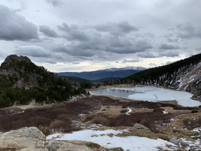
St. Mary’s Glacier

The hike to St. Mary’s Glacier is quintessential Colorado for a few reasons.

For the rugged and sweeping scenery.

For the easy access — that spoiled feeling we get only an hour’s drive from Denver.

And, let’s face it, for the crowds.

In-staters and out-of-staters flock to the trail reached off Interstate 70, past Idaho Springs. It’s a good one for your visitors who want a taste of the alpine. For beating the heat, it’s especially good in the summer — if you can get a parking spot.

Though the elevation starting above 10,000 feet might be more than your flat-lander guests bargained for. And however epic their desires, conditions might be too epic in the winter. The rocky trail is notoriously icy. There is also avalanche danger to consider.

Sign Up For Free: Denver Gazette Outdoors

Success! Thank you for subscribing to our newsletter.

function subscribeSuccess() {
var nsltrform = document.querySelector(“#nsltr”);
var nsltrSuccess = document.querySelector(“#successnsltr”);

nsltrform.classList.add(“hideblock”);
nsltrSuccess.classList.remove(“hideblock”);
}

function validateEmail(email) {
return String(email)
.toLowerCase()
.match(
/^(([^()[]\.,;:s@”]+(.[^()[]\.,;:s@”]+)*)|(“.+”))@(([[0-9]{1,3}.[0-9]{1,3}.[0-9]{1,3}.[0-9]{1,3}])|(([a-zA-Z-0-9]+.)+[a-zA-Z]{2,}))$/
);
}

function validateEmailAddress() {
const result = document.querySelector(“#result”);
const email = document.querySelector(“#email”).value;

result.innerText = “”;

if(validateEmail(email)) {
newsletterSubscribe(email);
} else {
result.innerText = ‘The email entered: ‘ + email + ‘ is not valid :(‘;
result.style.color = “red”;
}
return false;
}

function newsletterSubscribe(email) {
fetch(“https://services.gazette.com/mg2-newsletters.php?action=subscribe&site=denvergazette.com&emailPreferenceId=60&email=” + email, {
method: “POST”
}).then(res => {
console.log(“SUCCESSFUL POST”);
subscribeSuccess();
});

}

#nsltr {
min-width: 100%;
margin: 10px 0;
padding: 10px 20px;
background-color: #2076b3;

background-image: url(https://static.gazette.com/emails/circ/Audience%20Images/dg%20outdoors%20sign%20up.png);
background-size: cover;

}

#nsltr-header {
color: #fff4f4;
}
#nsltr-body {
text-align: center;
color: ;
}
#nsltr-button {
margin-top: 5px;
}
#successnsltr {
min-width: 100%;
margin: 10px 0;
padding: 10px 20px;
background-color: green;
text-align: center;
color: white;
}

#successnsltr a {
color: white;
}

.hideblock {
display:none;
}

h6 a {
color: black;
text-decoration: none;
padding: 5px;
background-color: #bbccdd;
font-weight: 600;
}

@media only screen and (min-width: 768px) {
#nsltr {
background-image: url(https://static.gazette.com/emails/circ/Audience%20Images/dg%20outdoors%20sign%20up.png);
background-size: cover;
}
}

Featured Local Savings

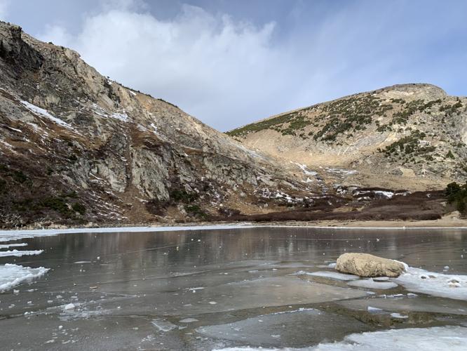
Whatever the season, if one is driving from the Front Range, one should be aware of the weather changes at the trailhead. It is, after all, the alpine. It can be especially windy out of the trees at the destination: a lake reflecting the vertical grandeur. It reflects, too, smiles that immediately come to first-timers.

If it’s your first time, you might be confused by trail branches along the way. The general rule of thumb is to continue uphill. Follow the small, trickling stream, directional downed logs and stacks of rock. You’re very unlikely to be alone, so you can always ask a fellow hiker if in doubt.

From the lake, one could continue on the trail north toward the summit views. It adds about another mile to the round trip.

Trip log: 1.1 miles round trip to the lake and back, 462 feet elevation gain, 10,839 feet max

Getting there: Going west on I-70, continue past Idaho Springs and take the exit for St. Mary’s/Alice. Go right and continue through the neighborhood, ascending a series of switchbacks for about 8 miles to the large parking lot (try a smaller one farther north if full). From the large parking lot, the rocky trail starts to the left about 100 yards up the road.

FYI: $5 fee for parking. Hiking only recommended. Dogs on leash. Icy in fall, winter and spring; wear traction.

SETH BOSTER, THE GAZETTE

ecbd3504-17eb-5971-9f4b-851559c67556

View Original Article | Split View

PREV

PREVIOUS

New trails open at Fishers Peak in southern Colorado

After years in busy Boulder and busier Denver, Juan Delaroca was looking for something else. In 2015, he found it driving through Trinidad near Colorado’s southern border with New Mexico — found it in the sight of a mighty flattop, Fishers Peak, which was privately held at the time. “I just kind of looked around and […]

NEXT

NEXT UP

Powder primer: A closer look at Colorado's ski areas

Facebook Twitter WhatsApp SMS Email Print Copy article link Save ARAPAHOE BASIN Claim to fame: A-Basin is known as “The Legend.” That’s partly due to its long season — known for more operating days than any other ski area in Colorado, typically opening first in North America and sometimes staying open through Independence Day. More […]