


Denver weather updates: Tens of thousands without power as snow continues to fall
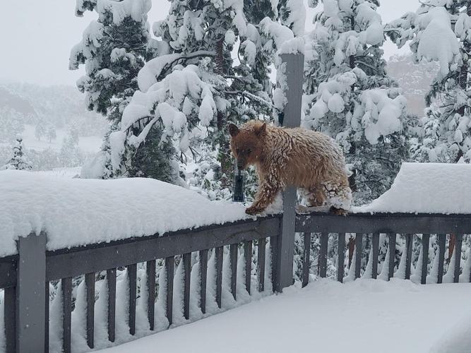
A bear cub visits a porch in Larkspur Saturday morning. Reader-submitted photo by Lucy Klee.
Denverites woke up on Saturday to a winter wonderland as a winter storm rocked Colorado and dropped between 1.7 and 14 inches of snow across the metro area.
Click or tap here for the latest road conditions around Colorado.
TODAY’S UPDATES
1:15 p.m. The National Weather Service has released updated snow totals:
- Air Force Academy: 13 inches
- Alma: 17 inches
- Aspen Park: 15.5 inches
- Aspen Springs: 18.6 inches
- Aurora 5.6 inches
- Berthoud Pass: 15.6 inches
- Black Hawk: 11 inches
- Black Forest: 13.7 inches
- Boulder: 8.3 inches
- Canyon City: 10 inches
- Cascade: 10 inches
- Castle Rock: 14 inches
- Colorado Springs: 10 inches
- Copper Mountain: 16.8 inches
- Crescent Village: 7 inches
- Cripple Creek: 20 inches
- Crook: 8 inches
- Denver International Airport: 2.3 inches
- Elbert: 15 inches
- Elizabeth: 14 inches
- Estes Park: 10.7 inches
- Evergreen: 9.9 inches
- Fairplay: 17.7 inches
- Florissant: 7 inches
- Fountain: 10 inches
- Franktown: 9 inches
- Genesee: 10.6 inches
- Golden: 14.5 inches
- Highlands Ranch: 8 inches
- Ken Caryl: 4 inches
- Lafayette: 4 inches
- Larkspur: 6 inches
- Leadville: 9.8 inches
- Longmont: 1.7 inches
- Louisville: 4.8 inches
- Manitou Springs: 9.0
- Monument: 16 inches
- Nederland: 13.6 inches
- Peterson Air Force Base: 10 inches
- Ponderosa Park: 12 inches
- Pueblo: 6.5 inches
- St. Mary’s Glacier: 12.5 inches
- Steamboat Springs: 6 inches
- Winter Park: 7.3 inches
- Woodland Park: 16 inches
1 p.m.: Xcel Energy says they are now working to restore power to over 80,000 Denver metro residents. There are nearly 1,700 outages that are impacting 80,747, according to the company’s outage map.
12:30 p.m.: All but one eastbound lane on Interstate 70 are closed between the Beaver Brook exit and Floyd Hill due to a trailer fire. A backhoe is removing the trailers cargo and fire crews are putting out parts of the fire that are smoldering, according to the Colorado State Patrol.
11:30 a.m.: The Global Dub Festival at Red Rocks Park and Amphitheatre has been canceled.
9:30 a.m.: Xcel Energy said over 450 employees and contractors are working to restore power to the tens of thousands of people who are currently without electricity.
9:10 a.m.: Denver parks and Recreation issues guidance on how to remove snow and manage damaged, fallen trees and branches in the wake of Friday’s snowstorm.
8:45 a.m.: Nearly 100 flights have been impacted at Denver International Airport due to the storm. 49 flights had been cancelled as of 8:45 a.m. while an additional 89 were cancelled, according to FlightAware
8:15 a.m.: Due the the heavy and wet snow brought by the storm system, over 67,000 people are without power in the metro area, according to Xcel Energy.
The largest outage is in the Littleton area and is impacting approximately 36,832 customers, according to the energy company’s outage map.
Officials did not estimate when power would be restored.
8:10 a.m.: CHSAA, after holding off on updates, announced Saturday that the track and field championships are set to resume at 2:10 p.m. at Jeffco Stadium.
7:45 a.m.: Cities and towns in the foothills and southern metro were the hardest hit since the snowstorm began as places like Evergreen received nearly 10 inches of snow, according to the National Weather Service.
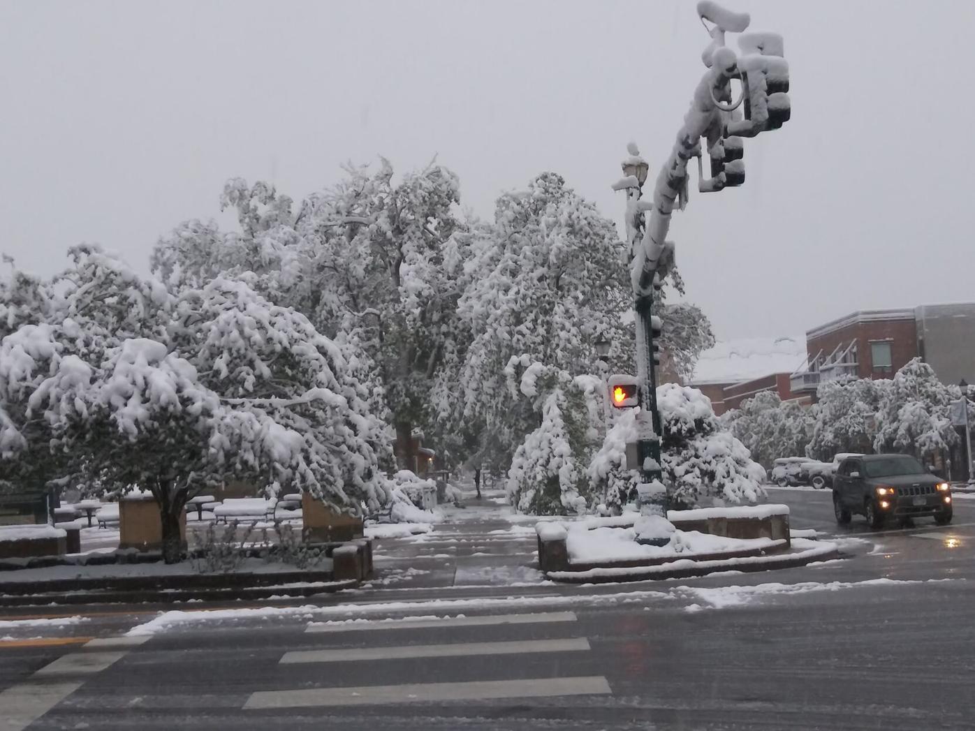
Snow weighs down branches on trees bordering Acacia Park in Colorado Springs Saturday morning.

Snow weighs down branches on trees bordering Acacia Park in Colorado Springs Saturday morning.
Denver’s official total as of 8 a.m. was 1 inch. The city’s official data is recorded at Denver International Airport.
Bands of moderate heavy snowfall are still possible this morning primarily south & west of Denver. Light snow elsewhere will still pose a threat to trees. Broken branches & downed power lines may lead to additional outages. Conditions should to improve by this afternoon. #cowx pic.twitter.com/UUDBJKjbQ4
— NWS Boulder (@NWSBoulder) May 21, 2022
Most of the precipitation in the Denver-metro will conclude by mid-morning, however, snow will continue south and west of Denver into the afternoon hours, according to the weather service.
Here are the preliminary snow totals from across the state as of 8 a.m.:
- Air Force Academy: 10 inches
- Aspen Park: 15.5 inches
- Black Hawk: 11 inches
- Black Forest: 16 inches
- Boulder: 3.8 inches
- Cascade: 10 inches
- Castle Rock: 3.5 inches
- Colorado Springs: 6 inches
- Crescent Village: 7.0 inches
- Crook: 8 inches
- Denver International Airport: 1 inch
- Elizabeth: 2 inches
- Estes Park: 5.5 inches
- Evergreen: 9.9 inches
- Florissant: 1.9 inches
- Franktown: 9 inches
- Genesee: 8.8 inches
- Highlands Ranch: 6 inches
- Ken Caryl: 4 inches
- Lafayette: 3 inches
- Larkspur: 6 inches
- Leadville: 9.8 inches
- Longmont: .3 inches
- Louisville: 4.8 inches
- Manitou Springs: 9.0
- Monument: 9.0 inches
- Nederland: 5.0 inches
- Peterson Air Force Base: 2.7 inches
- Ponderosa Park: 12 inches
- Pueblo: 6.5 inches
- St. Mary’s Glacier: 12.5 inches
- Steamboat Springs: 5.8 inches
- Winter Park: 7.3 inches
- Woodland Park: 16 inches
Here’s the forecast from the National Weather Service:
Today: Snow showers likely before 2pm, then a chance of rain showers. Some thunder is also possible. Mostly cloudy, with a high near 45. North wind 6 to 9 mph becoming south in the afternoon. Chance of precipitation is 60%. Total daytime snow accumulation of less than a half inch possible.
Tonight: A slight chance of rain and snow showers before 11pm. Mostly cloudy, with a low around 30. South wind 8 to 11 mph. Chance of precipitation is 20%.
Sunday: A chance of showers between noon and 3pm, then a chance of showers and thunderstorms after 3pm. Partly sunny, with a high near 57. Breezy, with a south wind 13 to 17 mph, with gusts as high as 28 mph. Chance of precipitation is 30%.
Monday: A slight chance of showers, then a chance of showers and thunderstorms after noon. Partly sunny, with a high near 60. South southwest wind 5 to 13 mph becoming north northeast in the afternoon. Winds could gust as high as 21 mph. Chance of precipitation is 40%.
Four tractor-trailers burned in Weld County truck stop fire
None None
none-none@midtc.com
Updated 3 weeks ago
1 of 1Crews cleaning up the fire that took ahold in four tractor-trailers at a truck stop in Weld County Wednesday night. Image courtesy of Mountain View Fire Rescue, via 9News .Courtesy of Mountain View Fire Rescue, via 9News Facebook...
None None
Reporter
Tesla Cybertruck towing wood chipper sparks wildfire in southwest Colorado
Marco Cummings
marco-cummings@midtc.com
Updated 4 weeks ago
1 of 5Smoke rises from the site of a fire involving a Tesla Cybertruck and wood chipper in Montrose County, Colo., on June 29, 2025. The incident triggered a wildfire that was later contained.Courtesy: San Miguel County Sheriff2 of 5The...
Marco Cummings
Reporter
One onboard helicopter that crashed into mountains near Meeker, FAA confirmed
Michael Braithwaite
michael-braithwaite@midtc.com
Updated 4 weeks ago
1 of 1Jacek Jacobi/iStock.comJacek Jacobi/iStock.com Facebook Twitter WhatsApp SMS Email Print Copy article link Save Only the pilot was onboard a helicopter that crashed near Meeker, about 40 miles northwest of Glenwood Springs, late Wednesday night, the Federal Aviation Administration...
Michael Braithwaite
Reporter
$9.9 million in lottery proceeds fund Great Outdoors Colorado grants
Scott Weiser
scott-weiser@midtc.com
Updated 4 weeks ago
1 of 2Photo Courtesy: Great Outdoors Colorado (GOCO)Courtesy photo, Great Outdoors Colorado2 of 2A bull elk bugles in open meadows at Moraine Park on the east side of Rocky Mountain National Park near Estes Park on Thursday, Oct. 8, 2021.The...
Scott Weiser
Reporter
Edwards protesters denounce Trump at rally
No User
no-user@midtc.com
Updated 4 weeks ago
1 of 3Edwards crowd listens to Paula Clements, a former U.S. Army officer who now lives in Eagle and works with Vail Eagle Indivisible, at No Kings rally Saturday, June, 14, 2025David O. Williams Special to The Gazette2 of 3No...
No User
Reporter
From big-city attorney to Colorado ranch hand helping save 200 horses from a wildfire
Carol McKinley
carol-mckinley@midtc.com
Updated 4 weeks ago
1 of 14Ami Cullen, head wrangler at C Lazy U Ranch in Granby, rides Squirt through the horse corral on Tuesday, Feb. 4, 2025. (Stephen Swofford, Denver Gazette)Stephen Swofford/ Denver Gazette2 of 14Ami Cullen, head wrangler at C Lazy U...
Carol McKinley
Reporter
Dozens of liquor shops shuttered after voters OK wine sales in grocery stores; hundreds more expected
David Migoya
david-migoya@midtc.com
Updated 4 weeks ago
1 of 5Bryan Morton, right, with E & J Gallo Winery and Jim Ruffcorn with the Brown–Forman Distilleries company help stock aisle three with wine on Wednesday morning, March 1, 2023, at the Safeway grocery store on South Havana Street...
David Migoya
Reporter
Dozens of Colorado water systems impacted after chemist caught manipulating data
Steve Staeger and Aaron Adelson 9NEWS
steve-staeger-and-aaron-adelson-9news@midtc.com
Updated 4 weeks ago
1 of 1FILE PHOTO: A water treatment operator tests water.Jerilee Bennett/The Gazette DENVER — The EPA has revoked a testing certification for the Colorado Department of Public Health and Environment’s (CDPHE) water quality lab, after an investigation found a chemist...
Colorado PUC seeking input on Xcel gas rate increase proposal
Scott Weiser
scott-weiser@midtc.com
Updated 4 weeks ago
1 of 2FILE PHOTO: The Colorado Public Utilities Commission is asking for public input on a proposed Xcel Energy natural gas rate increase.SBAYRAM/iSTOCK2 of 2U.S. Energy Information Administration records show a record price-spike for natural gas during the four-day February...
Scott Weiser
Reporter
Xcel Energy removing 118-year-old dam on the South Arkansas River headwaters
Scott Weiser
scott-weiser@midtc.com
Updated 4 weeks ago
Facebook Twitter WhatsApp SMS Email Print Copy article link Save A 118-year-old dam about five miles below the summit of Monarch Pass is about to be decommissioned and the dam removed. Xcel Energy said the dam and Unit 1 of...
Scott Weiser
Reporter